Feature Highlight: GSatTrack - Single Sign-On for Mobile Devices

GSatTrack has dedicated mobile apps for tracking the most popular mobile devices – iOS and Android phones and tablets. Both apps can be downloaded from the appropriate app store – either Google Play or iTunes by simply searching for GSatTrack.
These mobile apps have been published for a while now and allow you to track specific mobile devices on the GSatTrack platform.
Past vs Present
What’s new (and interesting!) is that we now support...
More
More
Feature Highlight: GSatTrack - Alert WorkFlow

Alerts are a powerful feature of any tracking and reporting platform. Alerts allow users to be notified in real-time about specific conditions met for an asset or group of assets that is noteworthy in some way. And often alerts are used to indicate issues that require a real-world response whether immediate or otherwise – such as when a driver is operating a vehicle recklessly, a driver needs emergency assistance, or a vehicle is simply due...
More
More
Universal CANbus solution remotely monitors vehicles and heavy machinery of all types
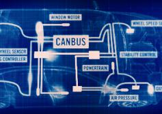
In today’s world, a Controller Area Network (CAN) is used in diverse industrial machinery which may consist of multiple microcontroller modules that need to communicate to each other for safe, efficient and uninterrupted operation and provide an extended functionality. Be it a refrigerating trailer unit or paver, a bus or a drilling rig, a truck or a combine-harvester, they all utilize a very sophisticated communication mechanism with...
More
More
GSatTrack provides security from international cargo theft
Cargo theft is estimated to cost shippers and trucking companies at least $30 billion a year in the US, according to the FBI. Most cargo theft occurs on the weekend and when the freight has been left unattended.
About GSatTrack
GSatTrack is a web-based, integrated satellite and GSM tracking solution, compatible with modern web browsers and works on a multilingual platform that brings together all the positions of every...
More
More
Effective fatigue management anytime, anywhere using Dual-Mode Satellite-Cellular

Safety and productivity in the workplace primarily depend on employees’ health. The road transportation industry in particular, has various hazards that potentially impact the psychological as well as the physical well-being of drivers. Shortage of quality sleep, night time driving, working and being awake for an extended period of time are the key causes of fatigue. It has been discovered that being fatigued significantly increases the risk...
More
More
Feature Highlight: GSatTrack - Asset Relation Alerts

There are many scenarios in which it is important to know when the relation-of-assets or groups-of-assets change with respect to one another. For example, if you have a convoy of trucks, shipping containers, or even people and need to know when one or more of those assets becomes separated from the rest. In the past this would normally require a portal operator monitoring the group of assets, but now GSatTrack supports automated alerts for when...
More
More
GSatTrack integrates fatigue management solution to save lives and increase productivity
The US National Highway Traffic Safety Administration conservatively estimates that 100,000 police-reported crashes are the direct result of driver fatigue each year. This resulted in an estimated 1,550 deaths, 71,000 injuries, and $12.5 billion in monetary losses this year alone. Because of these statistics it’s no wonder that trucking companies around the globe are now looking into fatigue management, especially in the mining sector.
...
More
More
Feature Highlight: GSatTrack - Route Geofences

For both small and large fleets of vehicles, efficient asset routing is an important factor in running a successful business. Ensuring drivers follow predefined routes is also often vital for several reasons; efficiency, safety and meeting regulatory requirements are just a few.
GSatTrack makes it easy to monitor asset routes with the ability to create a geofence from a driving directions route. There are a couple of ways to calculate a driving...
More
More
GSatTrack brings fleet management solutions to the forestry sector
The American transportation research institute lists compliance, safety and accountability as some the greatest concerns facing the trucking industry today. One of the major compliance concerns is the max weight that can be moved over the road. The weight being hauled by trucks can be used as an indicator of efficiency but also as a meter for safety by regulatory agencies.
The challenge facing most companies when meeting the weight regulations ...
More
More
Feature Highlight: GSatTrack - Asset Routing
Being able to create and monitor routes drivers take is an important part of fleet management operations. GSatTrack supports a number of methods to assign and monitor routes vehicles take.
Waypoints
The first, most fully-featured method is integration with a portable navigation device (PND) such as a Garmin screen installed in the vehicle. When a PND is installed in the vehicle, GSatTrack can offer real-time, two-way communications between the...
More
More
Pages
![]()